|
|
| Post Number: 11
|
GEOKARJO 
Google This!!!

Group: Members
Posts: 7799
Joined: Aug. 2003
|
 |
Posted on: Feb. 11 2005,8:47 pm |
|
   |
Posted for Jim Hanson
Attached Image
|
 |
|
|
| Post Number: 12
|
GEOKARJO
Google This!!!
Group: Members
Posts: 7799
Joined: Aug. 2003
|
|
Posted on: Feb. 11 2005,8:49 pm |
|
 |
Posted for Jim Hanson
Attached Image
|
|
|
|
| Post Number: 13
|
jimhanson

Group: Moderator
Posts: 8491
Joined: Aug. 2003
|
|
Posted on: Feb. 11 2005,11:48 pm |
|
|
Thanks, Geo.!
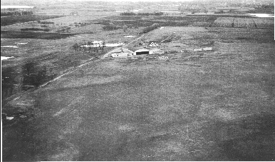
The first picture is of the airport in the early 50s--it was just a field, you could land any direction. If you can blow up the pictures, note the lack of houses along Bridge--no golf course, Bridge is just a gravel road--nothing around the fairgrounds.
The picture of the paved runway is 1955. Again, Bridge is only a gravel road--housing stopped at the fairgrounds.
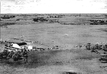
The next to last picture is looking south toward town--again, the town stops at the fairgrounds. Note the small lake where the golf course is--it ran across where the small park is located East of Bridge, and all the way out to Goose Lake.
The last picture is to the north and west. Note the lack of trees--most trees were used for heating and cooking up until and after the war--we have far more trees now than we did then.
Look to the West--the lake and old dump site is barely visible from this angle--old highway 13 and Wedge Nursery are visible as there aren't any trees.
--------------
"If you want to anger a Conservative, tell him a lie. If you want to anger a LIBERAL, tell him the TRUTH!"
|
|
|
|
| Post Number: 14
|
shaker

Group: Members
Posts: 435
Joined: Aug. 2003
|
|
Posted on: Feb. 12 2005,5:57 pm |
|
|
Jim, Broadway curved a little to the west, you see a little piece that juts out a bit, that was a turnaround. The long building just to the west side of N. broadway is the Town Club boweling ally. I can't make the court house out very good but I remember this, the jail was on newton and there was a large brick house attached to it, that was were the sheriff lived, It didn't go all the way to broadway it was still there when the 54 building was built. By the way I enjoy the old pictures.
|
|
|
|
|
|
|


